Project Introduction
Essex Community Development Corporation (Essex CDC) initiated and is leading a Traffic, Parking, and Pedestrian Safety Impact and Optimization Study for Eastern Boulevard. This study focuses specifically on improving the safety, accessibility, and overall usability of Eastern Boulevard for people who live, work, shop, and travel through Essex. The goal of the study is three-fold: 1) to document current conditions; 2) to identify feasible, implementable improvements that support a safer and more connected corridor that simeltaneously reflect community priorities, and 3) to identify funding mechanisms that Essex CDC can leverage to improve conditions on Eastern Blvd.
Study Overview
This Traffic, Parking, and Pedestrian Safety Impact and Optimization Study for Eastern Boulevard examines how people currently move along the corridor, including driving, walking, biking, parking, and transit use. It considers and evaluates traffic operations, pedestrian safety, parking utilization, crash history, and accessibility, and explores targeted improvement options for a safer, more walkable Eastern Blvd. corridor.
Focus Area
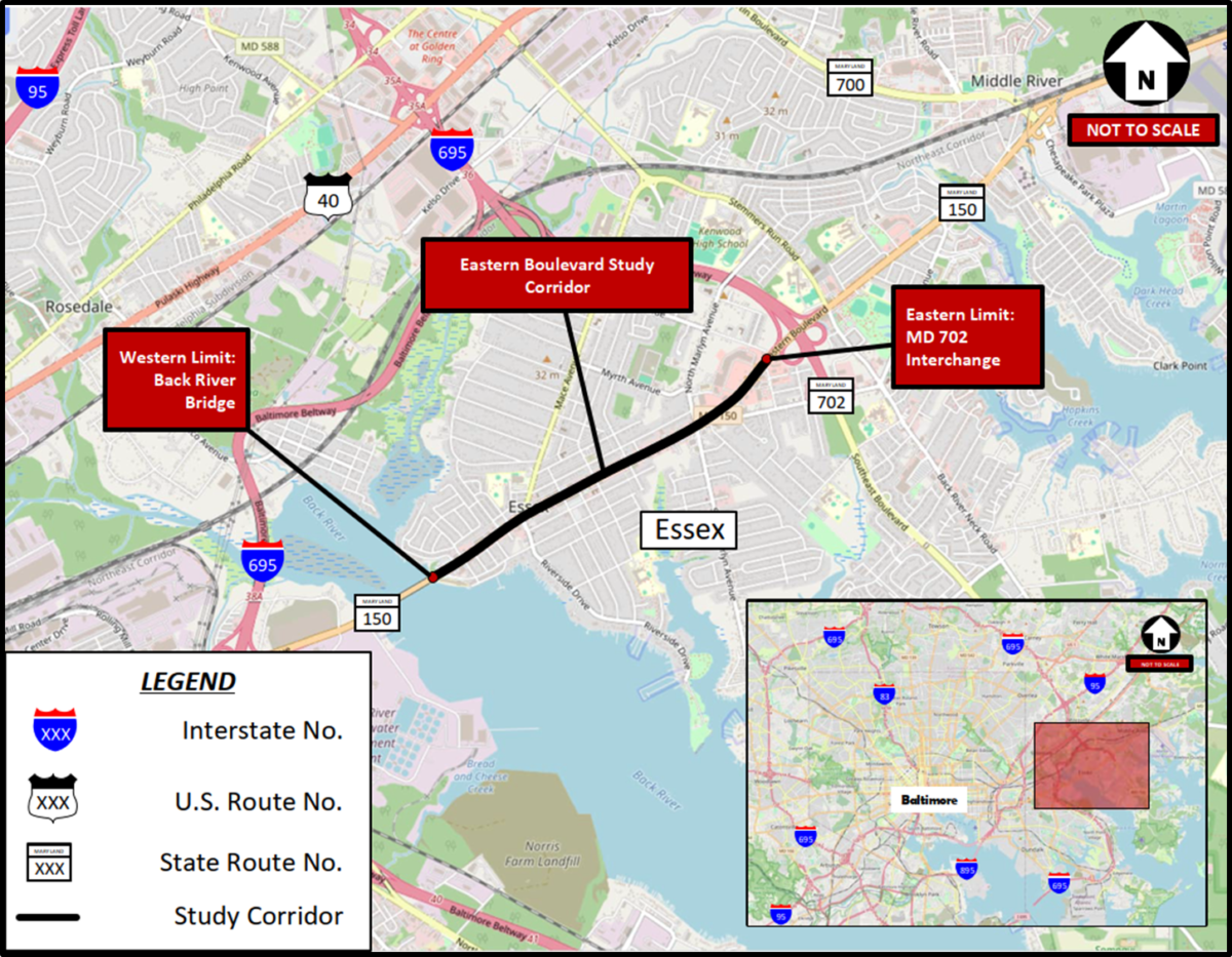
This work is focused specifically on Essex and the unique needs of the Eastern Blvd. corridor in Essex from the Back River Bridge to 702.
Why This Matters
Eastern Boulevard is one of Essex’s most important commercial and community corridors. Making improvements to safety, walkability, parking, and overall accessibility can:
- Improve quality of life for residents
- Support local businesses and economic activity
- Improve access to neighborhoods, schools, transit, and community destinations
- Make the corridor safer for pedestrians, cyclists, and drivers
Because Eastern Boulevard is a state road (not a Baltimore County road), there are specific steps required before any physical changes can be made to the roadway or its amenities. One of the first and most important steps is conducting a professional traffic study to understand current conditions.
This study will assess the current use of the road and identify safety concerns, traffic patterns, parking challenges, and pedestrian needs. It will also provide clear recommendations and outline potential funding sources that Essex CDC can pursue to help make these improvements a reality.
Community input is a critical part of this process. Your feedback helps ensure that the study’s recommendations reflect real experiences, daily challenges, and the priorities of people who live, work, and travel along Eastern Boulevard.
Funding & Project History
This traffic study is funded through the American Rescue Plan Act (ARPA), with funding provided to Baltimore County Government. In 2024, Essex CDC applied for and was awarded $200,000 by the Office of the County Executive to conduct this study.
The study is scheduled to be completed by the end of April 2026.
While several plans and reports over the last few decades have examined traffic issues and potential roadway changes in Essex, this effort represents the first comprehensive traffic study focused specifically on the Eastern Boulevard corridor from Back River Bridge to 702. As such, it is a critical step toward identifying realistic, implementable solutions that improve safety, connectivity, and access for everyone who uses the corridor.
Project Timeline
- September 2024 – March 2025: Study initiation and coordination with Essex CDC and partners
- March – July 2025: Data collection including traffic counts, parking studies, crash analysis, and site visits
- December 2, 2025: Community Input Meeting at Our Lady of Mt. Carmel School
- March 1 – 17, 2026: Public comment period via online feedback form
- March 18, 2026 | 5:00–6:30 PM: Community Input Meeting/ Open house at Essex CDC office
- March 18 – April 29, 2026: Development of final recommendations informed by public input
- April 30, 2026: Final report presented to Essex CDC
Consultant Team
The study is being conducted by Wallace Montgomery, a multidisciplinary planning and engineering firm based in Baltimore County with expertise in transportation planning, traffic engineering, pedestrian safety, and community-focused corridor studies. Wallace Montgomery is responsible for data analysis, development of improvement concepts, and supporting community engagement.
Community Input & Engagement
Community Input Meeting: held on Tuesday, December 2, 2025 | 5:30–7:30 PM at Our Lady of Mount Carmel (OLMC) School
Community Input Meeting Presentation and Materials are available HERE.
Public Comment Period: Sunday, March 8 – Tuesday, March 17, 2026
A Feedback Form Link is provided below. Community Members and Business Owners – please take this opportunity to provide your thoughts, questions, and feedback on proposed enhancements/changes.
Final In-Person Open House and Community Input Session: Wednesday, March 18, 2026 | 5:00–6:30 PM at the Essex CDC Office
This will be an Open-House-Style event with no formal presentation, providing an opportunity to meet the Wallace Montgomery Project Team and to ask questions and share feedback in person.
Community Input & Engagement (Update)
The materials currently displayed on the webpage reflect concepts presented during the December 2, 2025, Community Input Meeting and the March 2026 public comment period, including the March 18, 2026, Final In-Person Open House and Community Input Session.
On March 18, 2026, Essex CDC and Wallace Montgomery hosted a public workshop at the Essex CDC Office. This open-house-style event allowed residents, business owners, and stakeholders to review the proposed concepts, ask questions, and share feedback related to parking, traffic flow, pedestrian safety, business access, and corridor design.
Community feedback received during and after the March 18 meeting was reviewed by Wallace Montgomery and used to inform revised study materials and updated design concepts.
A follow-up public meeting will be held on May 11, 2026, to present updated concepts and gather additional community feedback. Residents, business owners, and stakeholders are encouraged to participate and help inform the study’s final recommendations.
Community Feedback Requested
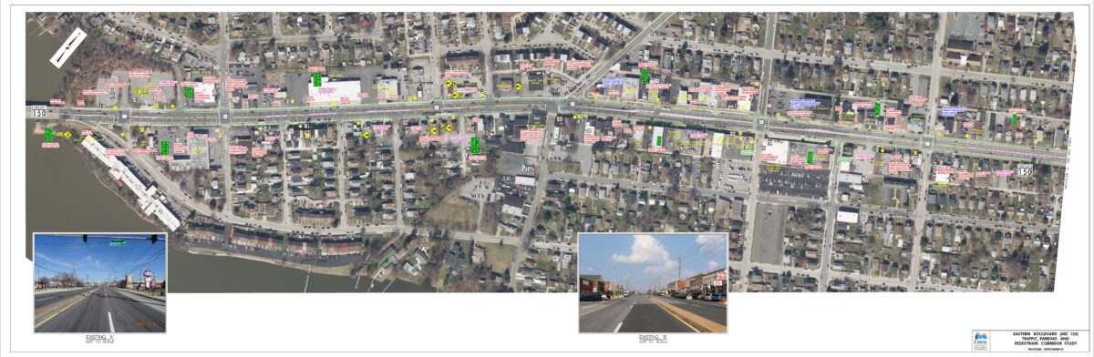
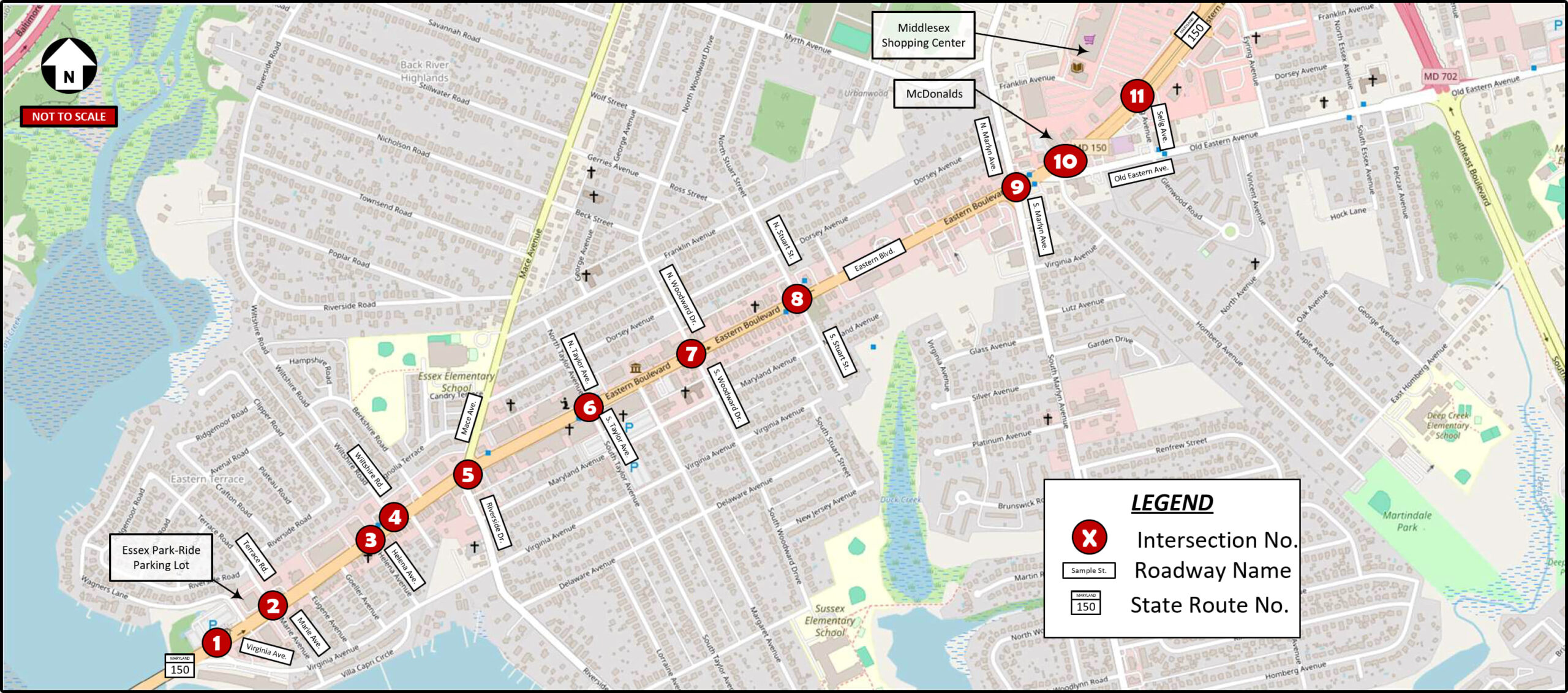
Below, you will find an image showing an Aerial Map of the Study Area with red dots identifying eleven (11) relevant intersections/locations along Eastern Boulevard. Below the larger map, each intersection is listed separately. Some intersections have their own designated map showing the specific intersection with proposed ammenities/improvements, while others simply are provided in list format.
A Glossary is provided below the images to explain what each symbol represents and what types of improvements are being considered. We encourage you to review the Glossary first, then look through the images.
After reviewing the images, please share your thoughts using the Feedback Form Link HERE. Your input will help guide the study’s recommendations and ensure they reflect real community needs and priorities.
Study Updates Following the March 18, 2026 Public Meeting
Following the March 18, 2026, Public Workshop, Wallace Montgomery reviewed community input and made several updates to the Eastern Boulevard Traffic, Parking, and Pedestrian Safety Study. These updates reflect community priorities related to parking, safety, business access, and corridor functionality.
Key Updates to the Study Design
Removed all proposed bike lane signing and pavement markings Maintained 8-foot parking-compatible outside shoulders (previously reduced to 6 feet for bike lanes) Reduced proposed median widths to 10 feet (previously 14 feet) to preserve left-turn lane functionality Maintained proposed left-turn lanes:
- From Virginia Avenue to Mace Avenue / Riverside Drive
- From Margaret Avenue to west of Marlyn Avenue
Added a new eastbound left-turn opening into Essex Plaza:
- Between Eugene Avenue and Goeller Avenue
- At Berkshire Road
Developed an optional center turn lane concept from Wagners Lane to Berkshire Road. Added proposed rumble strips for safety:
- Eastbound at Virginia Avenue
- Westbound near Middlesex Shopping Center driveway
Community Comments Summary
Feedback gathered during the March 18, 2026, workshop highlighted several recurring themes:
- Strong preference to retain on-street parking rather than replace it with bike lanes
- Concerns about median closures impacting business access
- Requests for safer pedestrian crossings and improved intersection design
- Ongoing safety concerns at key intersections, including Stewart Avenue
- Interest in tools such as speed cameras, signal timing improvements, and traffic calming measures
Revised Roll Plots
Updated roll plots were developed to reflect revisions made following the March 18 meeting. These revisions include:
- Removal of bike lane elements
- Adjusted shoulder widths to support parking compatibility
- Reduced median widths
- Updated turning movements and access points
- Additional safety improvements, such as rumble strips
These revised materials will be made available on the webpage for public review.
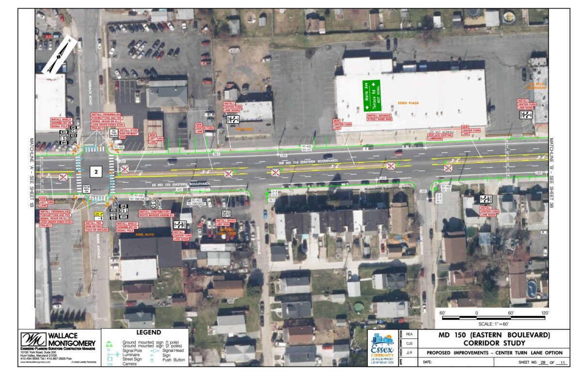
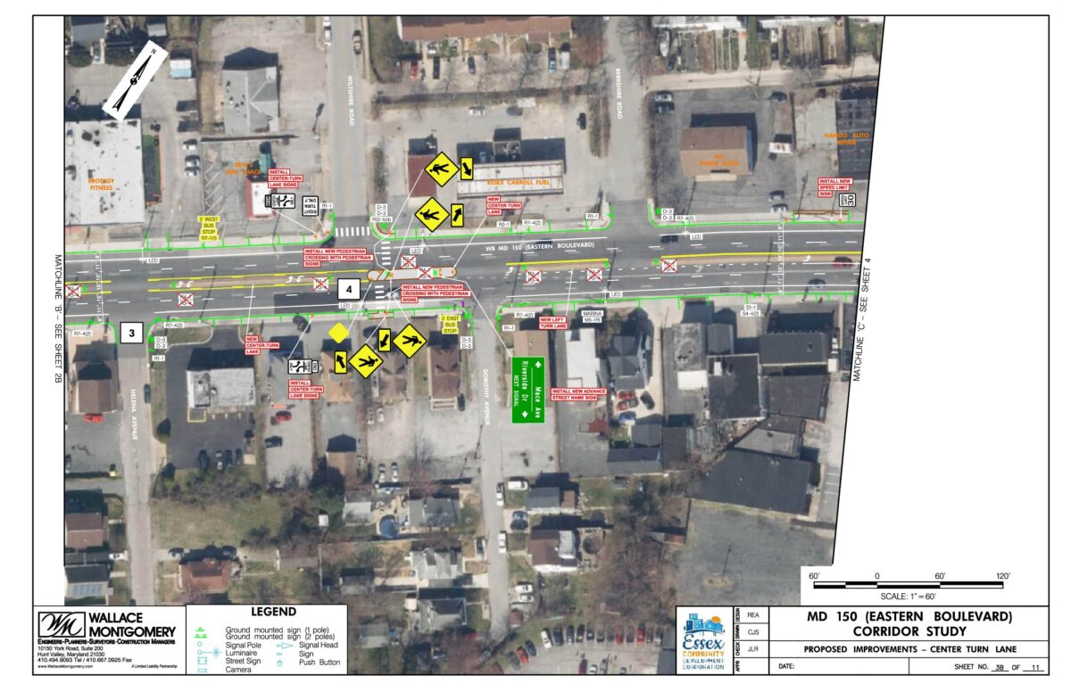
Center Turn Lane Option
A separate center-turn-lane concept was developed for the corridor segment between Wagners Lane and Berkshire Road.
This concept explores an alternative approach to:
- Improve turning access to businesses
- Reduce conflicts between through traffic and turning vehicles
- Enhance overall corridor functionality
This option will also be shared for public review and feedback.
Setting Expectations
- The study will inform recommendations shared with Baltimore County and the State of Maryland
- The study does not guarantee that all recommended changes will be implemented
- This effort is not a full redesign or reimagining of Eastern Boulevard
- The study does not include reducing travel lanes or adding roundabouts
- The focus is on practical, implementable improvements that improve safety, access, and connectivity
This study provides the foundation needed to advocate for future investments and improvements. Community feedback strengthens that foundation and helps ensure proposed solutions reflect local priorities and real-world conditions.
Aerial Map of Eastern Boulevard Study Area
Potential Overall Corridor Improvements
The following list includes recommendations for general improvements and ammenities throughout the study area:
- Install additional Speed Limit signs
- Install advanced intersection signs
- Geometric improvements to replace diagonal parking with parallel parking and wider shared-use sidewalks where on-street bike lanes are not provided (Riverside Drive/Mace Avenue to Margaret Avenue)
- Restripe narrower travel lanes (11′ outer lane, 10′ inner lane)
- Install left turn lanes at intersections without mainline left turn lanes and median openings
- Reconstruct wider medians with less side street openings
- Replace non-LED and non-operational existing luminaries with LED light fixtures
- Install signal head backplates to existing signal heads without backplates
- Install bike lane signage and pavement markings (Virginia Avenue to Riverside Drive/Mace Avenue and Margaret Avenue to Maryln Avenue)
- Replace undersized median signage with larger standard size signs
Intersection-Specific Potential Corridor Improvements
The following section includes detailed recommendations for specific intersections in the Study Area. Please be sure to refer to the Glossary below for definitions.
INTERSECTION 1: Eastern Boulevard and Virginia Avenue (Essex Park & Ride Lot)
- Install advanced intersection signage and route marker signage
- Install EB left turn lane
- Restripe pedestrian crosswalks with continental style markings and APS/CPS
INTERSECTION 2: Eastern Boulevard and Terrace Road/Marie Avenue
- Install advanced intersection signage and route marker signage
- Install continental style crosswalks with APS/CPS for east and west legs
- Install APS/CPS for south leg pedestrian crossing
- Install No Turn on Red signs for sidestreets
- Install Turning Vehicles Yield to Peds sign on sidestreets
- Remove trees for added visibility
INTERSECTION 3: Eastern Boulevard West of Helena Avenue
- Close median opening
INTERSECTION 4: Eastern Boulevard and Wiltshire Road
- Install advanced pedestrian signage and continental style crosswalk at east leg
- Install EB left turn lane
INTERSECTION 5: Eastern Boulevard East of Mace Avenue/Riverside Drive
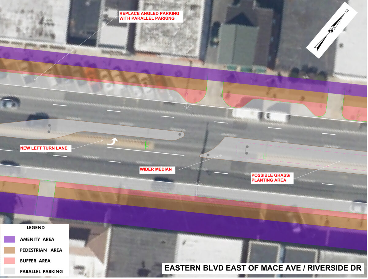
This aerial map focuses on a section of Eastern Boulevard to the East (towards Middle River) of Mace Avenue/Riverside Drive and identifies locations where pedestrian safety improvements, roadway enhancements, and streetscape upgrades may be considered. There is a Legend in the bottom lefthand corner showing the meaning behind the colors. Proposed improvements to this intersection are listed below:
- Install lane alignment pavement marking skips
- Install advanced intersection signage and route marker signage
- Install WB left turn lane
- Replace west leg crosswalk and pedestrian ramps and north and south leg crosswalks with continental type markings
- Install APS/CPS pedestrian signals for north and south leg crosswalks
INTERSECTION 6: Eastern Boulevard and N. Taylor/S. Taylor Avenue
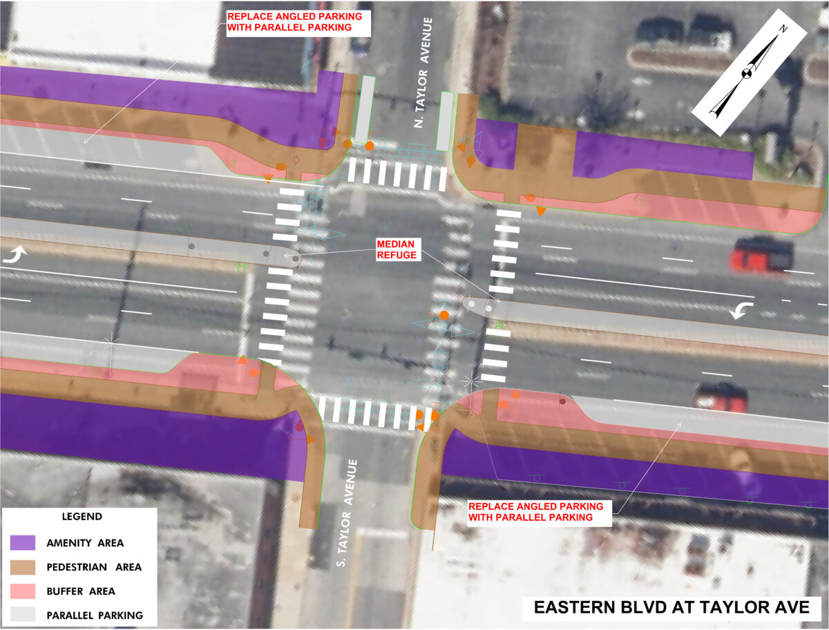
The aerial map focuses on a section of Eastern Boulevard at the intersection of Taylor Avenue and identifies locations where pedestrian safety improvements, roadway enhancements, and streetscape upgrades may be considered. There is a Legend in the bottom lefthand corner showing the meaning behind the colors. Proposed improvements to this intersection are listed below:
- Replace north and south leg crosswalks to continental style markings with APS/CPS for all legs
- Install advanced intersection signage and route marker signage
- Program Leading Pedestrian Interval (LPI) for east and west leg crosswalks
- Install No Turn on Red signs for SB Taylor Avenue
- Install Turning Vehicles Yield to Peds signs to sidestreets
- Upgrade nearside signal heads to all 12″ sections
- Replace standard size No U-Turn signs to existing signal mast arms
- Install new LED light fixture to NE corner signal pole
INTERSECTION 7: Eastern Boulevard and N. Woodward/S. Woodward Drive
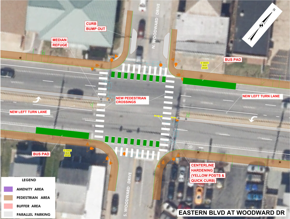
The aerial map focuses on a section of Eastern Boulevard at the intersection of N. Woodward/S. Woodward Drive and identifies locations where pedestrian safety improvements, roadway enhancements, and streetscape upgrades may be considered. There is a Legend in the bottom lefthand corner showing the meaning behind the colors. Proposed improvements to this intersection are listed below:
- Restripe north and south leg crosswalks with continental style markings and APS/CPS
- Install advanced intersection signage and route marker signage
- Install new continental style crosswalks on east and west legs with APS/CPS
- Install left turn lanes
- Replace Turn Restriction signs with larger signs
- Install new LED light fixture of NE and SW corners
- Install NB and SB No Turn of Red signs on signal mast arms
INTERSECTION 8: Eastern Boulevard and N. Stuart/S. Stuart Street
- Install left turn lanes
- Install pedestrian signs along MD-150 and continental style crosswalks for north, south and east legs
INTERSECTION 9: Eastern Boulevard and N. Marlyn/S. Marlyn Avenue
- Replace EB and WB left-turn signal heads with protected left-turn phase signal heads
- Install advanced intersection signage and route marker signage
- Install new west leg continental style crosswalk with APS/CPS
- Install NB and SB No Turn on Red signs on signal mast arms
INTERSECTION 10: Eastern Boulevard, Homberg Avenue and Old Eastern Avenue
- Install new continental style crosswalks on north, south and east legs with APS/CPS
- Install new sidewalk and crosswalk at Old Eastern Avenue and Homberg Avenue
INTERSECTION 11: Eastern Boulevard and Selig Avenue
- Install continental style crosswalks on north, south and west legs with APS/CPS
- Replace signal mounted luminairies with LED fixtures
- Install EB advanced intersection signage and route marker signage
- Install NB and SB No Turn of Red signs on signal mast arms
TO PROVIDE FEEDBACK, please be sure to SCROLL UP to the Community Feedback Requested Section and click on the Feedback Form Link.
Glossary of Transportation and Streetscape Terms
Accessible Pedestrian Signal (APS): A pedestrian crossing signal that provides tactile, audible push-button guidance that provides directions to blind pedestrians when held. Typically coupled with Countdown Pedestrian Signals (CPS) that use symbols for walk and don’t walk and a countdown timer that advises the number of seconds for pedestrians to complete their crossing.
Accessible Route (also called Pedestrian Access Route): A continuous path that is free of obstructions with design elements that meet the ADA and PROWAG. Accessible routes along State Highway Administration (SHA) maintained roadways must be at least five feet wide, with cross-slopes under 2%, no vertical discontinuities, and ramps down to street level and to storefronts.
All Red Pedestrian Crossing Phase: A signal phase that is dedicated entirely to pedestrians, often used in busy urban areas. Pedestrians may cross the intersection in all directions, including diagonally. All adjacent traffic is stopped with red signals. Also called a “Barnes Dance,” “Pedestrian Scramble,” or “Exclusive Pedestrian Interval.”
Amenity Zone: The part of a wide sidewalk space in front of a building that is dedicated to the adjacent use. For instance, restaurants could use the area for outdoor seating or benches; retail shops could place merchandise for “sidewalk sales.” Typically located in between the Pedestrian Zone and the physical building.
Americans with Disabilities Act (ADA): Policy and design guidance that ensures that all users, including those with disabilities, may access public spaces. PROWAG, or the Accessibility Guidelines for Public Rights of Way, further clarifies the design elements required along roadways.
Angle Parking: Skewed parking spaces adjacent to a roadway, where drivers either pull-in and back out into traffic (called Head-In Angle Parking) or back in and pull out into traffic (called Back-In Angle Parking). The parking spaces within the urban core of Essex along Eastern Boulevard are Head-In Angle Parking spaces.
Bike Lane: A designated lane for bicyclists, typically on the edge of road between the outside travel lane and the sidewalk. There may be a buffer between the sidewalk and bike lane, or in the case of Buffered Bike Lanes, between the roadway traffic and bicyclists.
Buffer: An area between the accessible route and the roadway that often includes grass or plantings. Signs, parking meters, utility poles, and other roadside features may also be located in the buffer area. The space between vehicular traffic and bicycle lanes may also be called a buffer.
Buffered Bike Lanes: Buffered bike lanes are typically on-roadway, and feature a separation between the bike lane and vehicular traffic. This separation, or buffer, may be designated with markings, flex-posts, curb stops, or a concrete median. Bike lanes buffred with concrete medians, parked vehicles, or barriers are often called Protected Bike Lanes.
Bus Pad: A concrete section of pavement in the outermost travel lane of a roadway near bus stops that absorbs braking and acceleration movements of buses better than standard pavement. Helps prevent pavement rutting at bus stops.
Chicane: A geometric feature placed within a roadway that forces traffic to abruptly shift to the left or right, geared to slow down drivers.
Continental Crosswalks: Crosswalk that uses thick striping oriented parallel to approaching traffic to increase visibility of the crossing to both drivers and pedestrians. State Highway Administration is using these types of crosswalks as a standard.
Curb Bump-Out (also called Curb Extension): A section of sidewalk and curb that extends into the roadway to shorten the distance that pedestrians need to cross. They may also frame the limits of parking areas to provide enhanced visibility to crossing pedestrians.
Curb Ramp: A depressed section of sidewalk or shared use path that allows users of the facility to cross streets without steps. Those using wheelchairs or bicycles will typically use curb ramps.
Detectable Warning Surface (DWS): A 24-inch wide high-visibility strip of raised circular “pips” placed across pedestrian ramps to indicate to pedestrians who are blind or have low vision that they are approaching a street crossing.
Flow Line: The location along the roadway edge that roadway runoff follows to reach inlets. One constraint that we have along Eastern Boulevard is to maintain the flow lines near their existing locations.
Green Pavement for Bicycle Lanes: Areas designated for bicyclists, or areas where bicyclists and motorized vehicles or buses may mix, are often highlighted with green paint to increase visibility to bicyclists and discourage illegal parking.
Inlet: A drainage structure used to convey water from the roadway to the underground drainage pipe network. May have bicycle-compatible grates or be constructed flush with the roadway curb.
Lane Width Reduction: A decrease in the width of a travel lane. On roadways where excessive speeding is a concern or lanes are not marked, providing 10-foot travel lanes may slow traffic and provide additional space for bicycle lanes or other features. Outside travel lanes that have a lot of bus or truck traffic are often not reduced beyond 11-feet.
Leading Pedestrian Interval (LPI): A traffic signal phase where all traffic has a red signal and pedestrians have a short interval (4-7 seconds) before there are any green indications for cross traffic. This allows pedestrians to enter the crosswalk and make them more visible to drivers.
Level of Service (LOS): A measure of the operations of a roadway based on a letter grade A to F. The Highway Capacity Manual defines LOS for signalized and unsignalized intersections as a function of the average vehicle control delay.
Level of Traffic Stress (LTS): A measure of the amount of traffic stress imposed to pedestrians and bicyclists on a rating scale for a particular road segment. The LTS levels are from 1 to 4 based on level of comfort, safety and interest for users.
Median: A raised, curbed feature that separates directional traffic. In the case of Eastern Avenue, the median separates eastbound and westbound traffic.
Median Hardening (also called Hardened Centerline): A length of mountable curb and flexible yellow posts that extend into an intersection to provide protection for crossing pedestrians in areas where there is not enough space for a median refuge. Passenger vehicles make turns around the flexible curb, while larger vehicles may cross over the flexible curb if needed.
Median Refuge: A section of sidewalk or shared use path built into the median that is wide enough to stop halfway across the intersection without blocking travel lanes.
Midblock Crossing: A marked crosswalk located between intersections. Typically includes continental markings, signage, and/or warning signals.
Parallel Parking: Parking spaces adjacent to the roadway where drivers park their vehicles facing the same direction as the traffic. Drivers typically must back-in to these spaces from the outermost travel lane.
Pedestrian Hybrid Beacon (PHB also called a HAWK Signal): A triangular-shaped traffic signal that is typically used mid-block to stop traffic so pedestrians may cross. When a pedestrian presses the button to cross, the signal begins to flash yellow, then goes to steady yellow, then two solid red inidicators appear. The WALK signal is active during this solid red phase. After a short duration, the red indicators will alternate flashing, and if the path is clear, drivers may continue through the intersection.
Pedestrian Traffic Signal: A standard red-yellow-green signal that is used at locations where there is a high volume of pedestrians crossing. Pedestrians have standard WALK/DON’T WALK signals.
Pedestrian Zone: The section along a wide sidewalk in commercial areas that is dedicated to pedestrians traveling through the corridor.Pedestrian zones should be a consistent material, must have cross slopes of 2% or less, and must be at least five feet wide along SHA roadways.
PROWAG, or Accessibility Guidelines for Public Rights of Way: Federally-mandated design guidance for sidewalks, ramps, road and driveway crossings, shared use paths, pedestrian signals, and other features to ensure accessibility for those with injuries or disabilities.
Raised Crossing: A pedestrian crossing that is placed flush with the sidewalk and creates a vertical “hump” for vehicles on the roadway. Primarily used as a traffic-calming measure.
Raised Intersection: An intersection that is at a higher elevation than the surrounding roadways. The crossings on all sides of the intersection are raised crossings, and the pavement between the raised crossings is also raised.
Shared Use Path: An access route that is typically wider than a standard sidewalk, where it is expected that pedestrians, bicyclists, equestrians, and other non-motorized users would share the space. Shared Use Paths may be adjacent to roadways (Sidepaths), or off-road routes.
Shoulder: A section of the roadway to the inside or outside of the travel lanes, used for emergency stopping, parking, or bicyclist use. Parts of existing Eastern Boulevard have wide shoulders that are used for parking.
Sidepath: An access route, typically wider than a standard sidewalk, that is used by pedestrians, bicyclists, and other non-motorized users adjacent to a roadway.
Speed Table: A design feature placed within the roadway that abruptly shifts traffic vertically upward for a short distance, and then back down to street level. The purpose of the speed table is to calm traffic. Similar to a speed bump or speed hump in its effects, less impactive to emergency vehicles.
Travel Lane: A part of the roadway that carries through traffic. In the case of Eastern Boulevard, there are typically two travel lanes in each direction.
Turn Lane: A part of the roadway that is dedicated to vehicles making left or right turns. These lanes typically have tapered entrances and extend for several hundred feet in advance of an intersection.
Unsignalized Crossing: An unsignalized crossing is a location where there are curb ramps and crosswalks without traffic signals. Static signs, warning lights, markings, or other methods may be used to indicate that pedestrians are present, and traffic must stop.
Utility Zone: The section of a wide sidewalk in a commercial area that is dedicated to overhead utilities, parking meters, signs, and other features. The Utility Zone often serves as a buffer or separation between parking areas and the Pedestrian Zone.
85th Percentile Speed: The speed at or below which 85% of drivers travel under free-flow conditions, reflecting the speed most drivers consider safe.
Frequently Asked Questions
What is the purpose of this study?
The goal of the study is three-fold: 1) to document current conditions; 2) to identify feasible, implementable improvements that support a safer and more connected corridor that simeltaneously reflect community priorities, and 3) to identify funding mechanisms that Essex CDC can leverage to improve conditions on Eastern Blvd. It focuses on Eastern Boulevard (Maryland Route 150) from the Back River Bridge to Maryland Route 702.
What are the goals of the study?
The goals of the study are to improve safety for motorists and vulnerable roadway users, enhance mobility for all users, foster economic development in the community, and promote a sense of place.
What happens when the study is complete?
Essex CDC will work with local and state government to prioritize changes to the roadway and secure grants to design and construct the proposed improvements. The final study report will be provided to the State Highway Administration to inform future projects along Eastern Boulevard in Essex. Essex CDC is working with consultant firm Wallace Montgomery to develop and present a conceptual design for review and comment by residents and business owners in the area.
Are other stakeholders, such as the County or utility companies, involved?
Yes, Essex CDC and Wallace Montgomery have been coordinating with the State Highway Administration; Baltimore County Revenue Authority and Department of Public Works and Transportation; and BGE and other utility companies with services within the project area.
Are there any constraints?
The study aims to minimize impacts to underground features, such as roadway drainage pipes and utility services. The design also must consider the mandated requirements for sidewalk widths and cross-slopes while accommodating the elevation differences between the roadway edge and the front doors to businesses.
What are the anticipated changes to parking spaces?
The current concept design eliminates the angle parking along Eastern Boulevard and replaces it with parallel parking within the central business district. Where there are businesses with parking lots adjacent to the roadway or residences with parking accessible from back alleys, the on-street parking along Eastern Boulevard is proposed to be removed and replaced with a bicycle compatible shoulder. Throughout the Eastern Boulevard study area, 197 of the 282 on-street parking spaces will be removed.